Natural Teruel
Guadalaviar Nature Trail
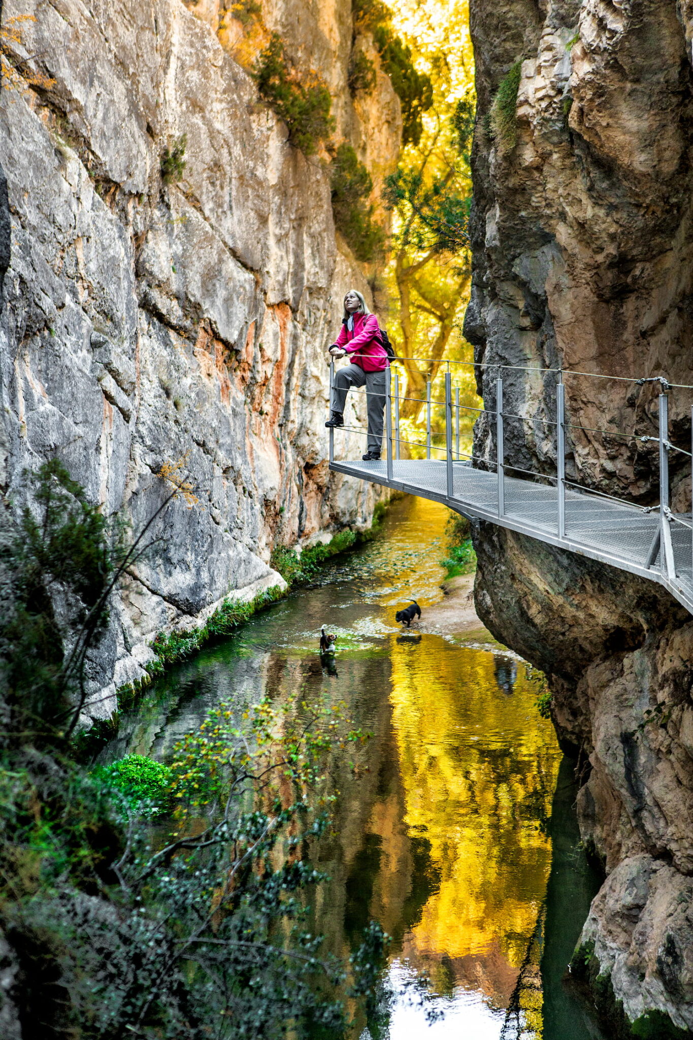
If what we want is something more rugged, the most recommended is the stretch of the Natural Path of the Guadalaviar River, which goes from the rural neighborhood of San Blas to the Arquillo reservoir. A well-conditioned path crosses the beautiful banks of the river and a narrow of vertical rocky walls through a hanging walkway. Its route is about three kilometers. The place is superb for a morning or an afternoon.

Via ferrata San Blas
The new via ferrata on the river path in the rural neighbourhood of San Blas, recently opened by the Teruel City Council, offer an exciting opportunity for sports and nature lovers. These routes allow you to enjoy the mountains in a privileged environment. The 'El Puente' route, at K2 level, is ideal for those who are new to this activity, while the 'Tres Puntas' route, at K3 level, presents a greater challenge for the more experienced.
These facilities, located in an ideal enclave, are perfectly integrated with the hiking routes in the area, thus enhancing the sports and tourist offer of Teruel. Enjoy the scenery, play sports and discover a new way to connect with nature in San Blas. Here you can find useful information for their use and enjoyment.
Arcillas Park
The city of Teruel has been recognized as a World Heritage Site since 1986, largely due to its exceptionally well-preserved historic center that houses notable examples of Mudejar and modernist architecture. The construction of this brick architecture and the production of high quality ceramics are historically related to the ceramic workshops and kilns of the neighborhoods of San Julián and Ollerías del Calvario, as well as to the clay extraction areas on the slopes near these workshops, at the foot of the hill of Santa Bárbara. In this way, the landscape of clay and pottery, always linked to the construction process of Teruel, has skilfully created a transition between the natural environment and the city, between the hill, the city and the Turia river.
The landscape of the Las Arcillas area presents a unique fusion between two opposing worlds. The pine forest descends the slopes of three twin hills and an adjacent platform, reaching the gates of the city. In between, there is a suburban space, characterized by a rapid succession of large areas opened by the industrial exploitation of clay, a four-lane road, barns and barns, some factory facilities and the first houses of the city.
MTB routes
Discover Teruel enjoying its surroundings
Our tourist proposal includes getting to know Teruel on your mountain bike and for this 12 routes have been signposted and promoted, which with varying degrees of difficulty and length allow you to enjoy diverse and natural places in the municipality, connecting in turn with the circular mountain bike route that connects Teruel with the 10 rural neighborhoods.
With the intention of highlighting the landscapes and mountains of Teruel, the City Council has launched an application with mountain bike users in mind, adapting and using new technologies and thus favouring the practice of outdoor sports.
The application, in addition to numbering and perfectly describing each of these routes, provides photographs as well as the track downloadable and usable by mobile phones as well as tablets and GPS. Some of these routes pass through places as familiar to the people of Teruel as the Alto de los Mansuetos, the Cerro de Santa Bárbara, the Peña del Macho or Las Gasconillas. In total they represent almost 170 km of routes in natural landscapes around the capital of Teruel. We also encourage Teruel fans of off-road cycling to discover Teruel enjoying its surroundings through these routes that can be found in btt.teruel.es.
Camino del Cid
The Camino del Cid is a tourist and cultural route that starts from Burgos, in Castilian lands, enters Aragon and ends in the southern territory of the Valencian Community. Its route goes hand in hand with the paths traveled by Rodrigo Díaz de Vivar as described in the poem of the Cantar de Mío Cid. It is signposted along its entire route and is suitable for hiking routes or largely secondary roads.
An important part of the road runs through Teruel, as reflected in its toponymy in places such as Poyo del Cid or La Iglesuela del Cid. In the north of the province one of its rings runs, among others, through towns such as Luco de Jiloca or Montalbán.
El Cantar de Mío Cid refers to Teruel in some of its verses:
He put Doroca in pariah, desi Molina who is from the other party, the third Teruel who was in front; in his hand he held Çelfa la de Canal.
When the corporal saw that Minaya was delayed,
with all his yentes he made an outdated night;
I left the Poyo, everything was unlocked, beyond Teruel Don Rodrigo Passava, in the pine forest of Tevar Don Roy Diaz posava.

The route that reaches the city of Teruel enters from the lands of Guadalajara and crosses the Sierra de Albarracín, from whose city it reaches Cella "the one of the canal" as the Cantar calls it. In this place, the Castilian hero will summon all the knights who want to accompany him to the conquest of the taifa of Valencia. From Cella the road that runs parallel to the highway reaches Teruel.
In the city of Teruel, travelers who make the Camino, can seal the safe-conduct that accredits their passage through our land in the Municipal Tourist Office located in the Plaza de los Amantes, number 6 and in the Tourist Office that the Government of Aragon has in the Calle de San Francisco next to the Escalinata.
Greenway Ojos Negros
When at the beginning of the twentieth century, the "Compañía Minera de Sierra Menera" decided to put into operation the iron mines of Ojos Negros in the province of Teruel, it entered into negotiations with the railway of the Central de Aragón to carry out the transport of the mineral. By not reaching an economic agreement, it will be the company itself that builds a new railway line that will largely run, parallel to the existing one, to Sagunto. Through this port it exported the mineral and from 1923 it supplied the new blast furnaces that were installed in Sagunto.
Work on this new line began in 1903 and was completed four years later. One meter wide and 204 kilometers long, the line crossed the provinces of Teruel, Castellón and Valencia and had 19 stations. The Ojos Negros-Sagunto railway operated for sixty-five years, except for the time between 1933 and 1940 that remained stopped due to social conflicts and the Spanish Civil War. In a readjustment of the company in 1970 the lifting of the railway was decreed and the last transport would be carried out in 1972. When the blast furnaces of Sagunto were dismantled, the Sierra Menera Mining Company stopped working.
Currently a large part of the route of this line has been transformed into a greenway.
We will enter Teruel, through a route of more than 90 kilometers, we can reach Santa Eulalia del Campo.
The route runs through the high lands of Teruel, bordering on an altitude of one thousand meters, which are widely exceeded in the vicinity of the Puerto de Escandón where it exceeds 1200 meters.
This rugged terrain is saved by five tunnels and thirteen viaducts, some of them beautifully executed such as the Albentosa with its 50 meters high.
From Santa Eulalia to Ojos Negros it is not conditioned as a greenway but some local roads, narrow and with quiet traffic, invite you to make the route.
Arriving in the vicinity of Teruel, after the descent of the Escandón and up to the Los Baños station, several links invite you to leave the route and in a few kilometres come to visit the city, to enjoy a tourist walk, regain strength and stock up on what you need.
Rambla Barrachina
To the southwest of Teruel is one of the most unique places that surround the city, it is the Rambla de Barrachina. Its access does not present excessive difficulties and can be done from the road to Cuenca. Along this ravine that carries the waters from La Muela to the Turia River, huge gullies rise on its banks. These steep verticals, which can be seen from a distance, transport us to the landscapes of the cinema of the "far west"
Ribera del Turia
To take a walk or do some sport stretching your legs there is nothing better than approaching the riverbank as it passes through the city. A well-kept path of recent creation, which is accessed from the Iron Bridge or the Tablas bridge, provides us with the right place next to the waterway in the middle of the riverside vegetation. Its extension goes from the Cube bridge to downstream of the railway station.
Way of the True Cross
The Camino de la Vera Cruz from the Pyrenees is a route that pilgrims travel from the mountain range that gives it its name to the town of Caravaca de la Cruz, where a relic of the Cross is venerated in which Jesus Christ was crucified and found by the Empress Santa Elena.Caravaca de la Cruz is one of the three holy cities of the Iberian Peninsula, place of permanent pilgrimage since the granting in 2003 by the Holy See of the Jubilee Year in perpetuity. There are several historical and literary references that narrate this pilgrimage through the Iberian Peninsula.
A route that crosses Navarre, runs through Aragon, Valencia and Castilla-La Mancha, until it reaches the Region of Murcia. Almost 900 kilometers that today have been recovered and put in value to attract new pilgrims; those who, emulating the travelers of yesteryear, today render worship and devotion to the Most Holy and True Cross of Caravaca.
Ricardo Eced Fueros Park
If you want to enjoy a large green space within the city and enjoy the great variety of vegetation existing in the park you only have to move 10 minutes from the historic center to find this park. It has multiple play areas for the little ones, including a small zip line, walking areas and its "amphitheatre" where you can enjoy musical activities, plays, and the best films in its summer cinema.
It has a spectacular castle for recreation, a large children's playground. The attraction, in the shape of a medieval castle that in its different rooms has slides, walkways, climbing area and other elements to play and have fun.
Also, if you want to practice sports without leaving the city. It is an ideal place for running, has a semi-hard perimeter terrain of gravel of almost 1km. In addition to this, it has volleyball and football courts, and is signposted with points for very fun orientation activities. To finish with the sports options, it has a small outdoor sports / crossfit facility.
Services:
Bar restaurant. Bar Parque los Fueros
Public toilets (Los Paules exit area)
Location: Ronda del Parque (Barrio del Ensanche)
Rural neighborhoods
In addition to the urban core, Teruel has ten rural neighborhoods located within a radius of about 12 km. around the city. A tour of them leads us to know a more relaxed model of life due to the population they have, which at most reaches a few hundred inhabitants.
On one of these tours we could visit Castralvo, La Aldehuela and Villaspesa. Starting from the second roundabout of Avda. Sagunto of the city, leaves a road that, after traveling about four kilometers will bring us closer to Castralvo. Located on the left bank of the Rambla de Valdelobos, next to the people who always inhabited it, it has now become a place of quiet residences. Continuing along the same cart another seven kilometers we will reach La Aldehuela. Located in the foothills of the Javalambre massif, its term enjoys magnificent natural landscapes and fountains, such as La Hortaleza, with an abundance of water and in a privileged environment. Mention to part deserves the fountain of La Aldehuela, within the urban area. It dates from 1724, is neoclassical in style and has great architectural interest.
Access to Villaspesa is very simple. Without entering Teruel, and through the ring road towards Zaragoza, is the detour that takes us to this classic rural neighborhood. Traditionally agricultural, on the left bank of the Turia, today it is also a residential neighborhood. The visitor can not miss a small jewel of Teruel modernism such as the church of El Salvador by Pablo Monguió.
Undoing the path traveled, within the industrial estate and at its first roundabout, we find the detour that takes us to Concud after traveling about 5 kilometers. Their houses rise next to the Regajo, which carries its waters to the Alfambra River. To highlight the paleontological richness of the Barranco de las Calaveras and the Cerro de la Garita, sites with important fossil remains of the mammal fauna of the Turiolense in the Upper Miocene, 7 million years ago. These sites have been declared Assets of Cultural Interest.
From Concud there is a road that takes us to Caudé, although without a proper car it would be better to return to the national road to make a somewhat longer journey. In Caudé we will find a baroque church of the eighteenth century dedicated to Saint Thomas of Canterbury. Very interesting are the wrought iron works that can be found in its streets. In its term, on what was a former military aerial shooting range, airport facilities with a long runway have been built.
We have a third route that will take us to Valdecebro, Tortajada and Villalba Baja. To make the road we will take the road to Alcañiz leaving the north of the city and, when we reach the roundabout to access the highway, we will take the direction to Cantavieja that will take us, after traveling about seven kilometers, to the rural neighborhood of Valdecebro. It is located in the middle of a beautiful countryside, with abundant pine forests, holm oaks and oak groves, on the left bank of the Río Seco riverbed.
Returning to the roundabout of the highway and heading towards Alcañiz, we will arrive in Tortajada on a route of about seven kilometers. The nucleus of houses of Tortajada is located next to the river Alfambra and the old orchards of its irrigable area have become endless poplars. In its terminus and not far away, it is interesting to have an excursion to the small lagoon of the same name.
Following the Alcañiz road for another couple of kilometres you reach Villalba Baja. The road crosses the interior of the neighborhood and the Alfambra River borders their houses. Orchards and poplars occupy the banks of the river and beyond, the limestone terrain produces a landscape dedicated to rainfed crops. Interesting, bordering the town, is a ravine with abundant caves.